GEOGRAPHY/MAIN FEATURES :
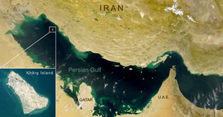
Kharg Island is in the northern part of the Persian Gulf and lies about 30 Km from the Iranian mainland between the north latitudes 29 12’ to 29 16’ and longitudes 50 17’ to 50 20’ east. Island is surrounded by deep water of sufficient depth for the largest crude tankers now in service.
AUTHORITY:
-
National Iranian Oil Co. (N.I.O.C)
APPROACH/ANCHORAGE:
Ships approaching Kharg from south, should keep at least 4 Km to the east of the Island. Vessels approaching Kharg from the north should keep to the west of the Island (outside the restricted area) as Kharg Island at the north is very low lying and difficult to see until dangerously close to.
On arrival at Kharg, all vessels including those destined for SEA ISLAND, should proceed to the approved anchorage area which is located to the east of the eastern boundary of the harbor limits. Ships must await instructions and not enter the harbor limits unless a berthing master is on board.
ACCOMMODATION:
-
N I O C Oil Loading Terminals
-
Kharg Chemical Complex Sulphur/LPG Terminal
OIL LOADING :
Both Iranian Light and Heavy crude oil are available at all oil berths. Crude oil is delivered to the terminals from the tank farm, elevated 62 m AMSL, situated on the central plateau of the Island , by gravity flow through pipelines.
A-1) TEN BERTH " TEE" OIL LOADING JETTY :
The jetty is a "TEE" head which has an overall length of 1840 m, connected to the shore 1100 m away by a piled trestle and rock filled causeway. The jetty with depth alongside 17-21 m, is designed to handle large tankers, three berths (No. 3,5 & 7) can accommodate VLCC tankers of 300000 tons dwt, and Aframax tankers will accommodate alongside the other berths. Deck level is 6.7 m above chart datum. The berths from north to south are numbered as follows :
-
Outer berths : 9,7,1,3,5
-
Inner berths : 10,8,2,4,6
Each berth is provided with a Chiksan loading unit, fitted with hydraulically operated loading arms. Loading rates of max : 15000 tph to one berth can be achieved under favourable conditions.
A-2) SEA ISLAND FOUR BERTH LOADING TERMINAL :
Sea Island Terminal is located close to the west coast of the Island. It is designed to accommodate ULCC tankers of 500000 tons dwt at two outer berths No. 11 & 15 on the west side with depth alongside 32 m and vessels of max. 330000 tons dwt at inner berth No. 12 on the east side with depth alongside 29 m. Berths are equipped with Chiksan loading units and loading rates of max. 30000 tph to one berth can be achieved under favorable conditions.
A-3) DARIUS SEA LOADING OIL TERMINAL (SPM) :
It is an open unsheltered roadstead located to the south east of the Island. Ships loaded by means of submarine pipeline at a single berth approx 1.6 Km offshore in over 20 m of water.
B) SULPHUR & LPG LOADING TERMINAL :
A combined LPG & Sulphur loading berth exists on the south east corner of Kharg Island. Single berth with depth alongside 12 m consisting of one main and eight mooring dolphins can accommodate vessels of about 40000 tons dwt for loading of Crushed Sulphur and LPG.