Bandar Abbas
BANDAR ABBAS is divided in two sections: new port named Shahid Rajaie Port Complex, and old port called Shahid Bahonar .
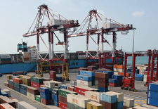
BANDAR ABBAS ( NEW PORT : SHAHID RAJAIE )
GEOGRAPHY/MAIN FEATURES :
This very large complex is situated on the foot of Kashar and Gachin mountains.30 kms west of city of Bandar Abbas, that’s about 56º04 ' E and 27º 07' N.
The construction plan of the port comprised a maneuvering main basin and three subsidiary basins having berths, warehouses, wharfs and buildings with related facilities. There are projects approved for developing of this complex, the most important ones, a silo for grain storage, a fishing & coastal traffic harbour, expansion of cargo and container storage areas and many others.
All seamen may use the recreational facilities of the Seamen’s Club. It is built to Iranian traditional architecture, offers a very pleasant atmosphere. Seamen may also do shopping at the stores in this place and buy Iranian handicrafts.
SPECIAL ECONOMIC ZONE :
Iran’s high council of Free Trade Zone, recently ratified Bandar Abbas as a special economic area. The special status of the port located at the Strait of Hormuz at the entry of the Persian Gulf offers a gateway for re-exports to and from Central Asia through its direct railway link as well as with the rest of Iran’s network. It offers the best port facilities with 24 loading booths for ocean liners together with a range of well-equipped storage facilities, including mechanized, indoor and open-top. The zone is open to companies in the PG or elsewhere in the world to take advantage of the benefits from the special regulations. Incentives include the lack of tariffs and customs procedures. Manufacturers or Traders can rent space at preferential rates on a long-term basis to build their own required facilities.
APPROACH/ANCHORAGE :
The Vessel Traffic Services (VTS) system is operational. Vessels proceeding to the port should one hour before entering the Traffic Separation Scheme areas, contact the Vessel Traffic Center on VHF channel 13 to get permission to enter the traffic lanes. The position of embarkation and disembarkation of pilots regarding Bandar Abbas TSS is two miles from the turning beacon of the port. The entrance channel 249 x 6500 m depth 13.5 m capable of letting two ships pass at the same time
ACCOMMODATION:
|
TYPE OF BERTHS |
POST(s) |
LENGTH(m) |
DEPTH(m) |
|
General cargoes |
10 |
2000 |
11-14 |
|
Special cargoes (dry bulk,…) |
4 |
720 |
11-14 |
|
Container terminal |
5 |
1000 |
14 |
|
Multipurpose (liquid bulk,…) |
2 |
400 |
11-14 |
|
Ro/Ro platform/passenger |
1 |
100 |
9 |
|
Liquid/ oil export, import (double) |
2 |
440 |
11.5 |
|
Foulad oil terminal (for discharge of crude,…) |
1 |
250 |
13 |
|
Private oil transit pier (STC Quay) |
1 |
< 200 |
8-10 |
|
Barge service berths |
- |
240 |
- |
EQUIPMENT :
Due to modernization policy new and modern hoisting and cargo handling machineries have been purchased. These include gantry cranes, shore cranes, high lifting capacity mobile cranes, hoppers for cereal, hydroelectric grabs and many others.
NOTE : The port can accept Bulk Carriers of up to 100.000 tons dwt and also large tankers of up to 80000 tons dwt for load /discharge of different Dry/Liquid bulk commodities.
WAREHOUSES & PORT AREA :
-
Port area: 1,598,000 square meters
-
Warehouse : 164,000 square meters
-
44,220 square meters (under construction)
BANDAR ABBAS ( OLD PORT : SHAHID BAHONAR )
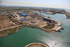
GEOGRAPHY/MAIN FEATURES :
The port of Shahid Bahonar is located in 27º08' N and 56º12' E from the sea position in north of Qeshm Island at the entrance of the Persian Gulf.
Due to its strategic geographical location, government’s developmental plans, construction of Shahid Rajaie Port Complex and execution of many industrial projects the last and the most important one the Bandar Abbas Refinery, which play a major role in the country’s economy, Bandar Abbas acts as the main gate to the region’s economy.
Shahid Bahonar port is located 8 km west of city of Bandar Abbas and is connected to Tehran and other cities by air, paved roads and newly opened railway system.
APPROACH/ ANCHORAGE :
The Vessel Traffic Services (VTS) system is operational. Any vessel coming from eastern side of Strait of Hormuz or the Gulf of Oman and proceeding to the port of Bandar Abbas should one hour before entering the TSS (area A), contact the vessel traffic center (VTC) on VHF channel 13 to get permission to enter the traffic lane of TSS (area A) between Larak & Hormuz Islands. And vessels coming from the Persian Gulf, should one hour before entering the TSS (area B), contact the VTC authority on VHF channel 13 to get permission to enter traffic lane of TSS (area B) between Qeshm & Larak Islands. All vessels in the TSS region should deep watch on VHF channel 16, and the speed limit will be 12 knots. The position of embarkation and disembarkation of pilots regarding Bandar Abbas Traffic Separation Scheme (TSS) is two miles from the turning beacon of the port.
ACCOMMODATION:
|
TYPE OF BERTHS |
POST(s) |
LENGTH(m) |
DEPTH(m) |
|
General cargoes |
6 |
1050 |
10 |
|
Ore loading (Navarsang) |
1 |
190 |
10 |
|
Oil load / discharge (Charlie 1 & 5 ) |
2 |
380 |
10 |
|
Passenger terminal |
1 |
190 |
10 |
|
Barge jetty |
1 |
250 |
8 |
SHORE GEAR :
Hoisting machinery of various capacities and cargo handling machinery of different types are available.
WAREHOUSES AND PORT AREA :
-
Port area : 300,000 square meters
-
Warehouse : 90,000 square meters